Comprehensive Description
provided by Smithsonian Contributions to Zoology
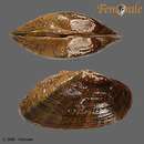
Alasmidonta (Decurambis) marginata Say, 1818
Alasmidonta marginata Say, 1818:459, 460. [Type-locality: Scioto River [Ohio]. Type-material not in the Academy of Natural Science of Philadelphia (Baker and Johnson, 1973) and presumably lost.]
[?] Mya rugulosa Wood, 1828:3, pl. 1: fig. 7 [of Mya]. [Type-locality: “North America, Fresh Water.” Type-material not in British Museum (Johnson, 1971) and presumably lost. Identification uncertain.]
Alasmodon (Decurambis) scriptum Rafinesque, 1831:4. [Type-locality: Green River [Kentucky]. Original type-material lost.]
Margaritana marginata “var. truncata” B. H. Wright, 1898:124. [Type locality: “occurs in eastern as well as western waters and into Virginia and Tennessee.” Lectotype in Smithsonian Institution, USNM 150545, from Clinch River, Virginia (Johnson, 1967 (a):9).]
Alasmidonta (Decurambis) marginata susquehannae Ortmann, 1919:187, pl. 12: fig. 4. [Type-locality: Susquehanna River Selinsgrove, Snyder Co., Pennsylvania. Syntypes in Carnegie Museum, 61.4679.]
Alasmidonta marginata variabilis F. C. Baker, 1928:194, pl. 69: fig. 4–9. [Type-locality: Red Cedar River, near Cheteck, Barron Co., Wisconsin. Lectotype in the Museum of the Wisconsin Geological and Natural History Survey, University of Wisconsin, catalog number 935a (Franzen, 1957: 33).]
THE SHELL
DESCRIPTION.—Shell ovate-trapezoidal in shape; up to about 110 mm long, 54 mm high, and 46 mm wide; and thin or of medium thickness (up to 3 mm thick anteriorly) and fairly strong. Anterior margin evenly rounded; ventral margin broadly and flatly curved throughout or centrally straight (or even slightly concave); posterior margin abruptly rounded to biangulate below, diagonally and flatly curved above, and in many species, concave centrally: dorsal margin long and flatly curved. Maximum inflation at posterior ridge behind center of shell. Beaks broad, moderately elevated, located above the hinge line. Posterior ridge prominent, strong, high, and sharply angled. Posterior slope broad, truncated, and flattened or concave.
Annual growth increments marked by grooves with dark periostracum, but other low concentric ridges also cover the surface. Other post-juvenile sculpturing consisting of crowded, rather strong, low corrugations, at right angles to lines of growth, and covering all of the posterior slope or fading out before reaching the posterior margin. Periostracum yellowish brown with wide and narrow green rays. These are particularly prominent in juveniles but as the background color darkens in adults they become less apparent. Ligament strong, broad, and of medium length.
Hinge teeth moderately well-developed but incomplete. Pseudocardinal teeth narrow, dorsoventrally compressed, erect, pointed, directed anteriorly, and numbering 1 in the right valve and 1 in the left. Interdental projection in left valve prominent, irregular, lamellate, more or less confluent with the pseudocardinal tooth, and articulating with a depression in the right valve. Lateral teeth vestigial and indicated only by a short, poorly defined, proximal, lamellate protuberance in one or both valves. Beak cavity excavated but not deep. Anterior muscle scars impressed, pallial line shallow but clearly discernible in most specimens, posterior muscle scars shallow and not well-defined, and scars within beak cavity consisting of two short parallel grooves with marginal ridges parallel to the hinge plate and located on the back of the hinge plate posterior to the pseudocardinal teeth. Nacre white or bluish white, glossy and (in some individuals) slightly iridescent posteriorly. A high proportion of specimens from the Susquehanna River system, and a few specimens from elsewhere, have pinkish or reddish suffusions. The edge of the shell is bordered by a greenish or grayish band or (in some specimens) the marginal nacre is so thin that external periostracal colors are visible.
Beak sculpture coarse and composed of about 5, broadly double-looped, rounded ridges, all terminating at the posterior ridge, the outermost of which extends about 12 mm beyond the umbonal apex. Ridges best seen in young specimens or specimens from hard water.
VARIATION.—Baker (1928) has shown that at least two well-marked ecophenotypes exist in this species, a form living in creeks and small rivers (“typical” marginata) in which the shell is more cylindrical and smaller than the form occurring in large and medium-sized rivers (truncata). In form marginata “the distance from anterior end to umbones varies from 31 to 36 percent, while in the large river form [“truncata”] it varies from 33 to 47 per cent” (Baker, 1928:192). This trend is amply demonstrated by the material available in the Smithsonian Institution and, since Baker clearly indicated that “truncata” is an ecophenotype of marginata sensu stricto, there is no taxonomic need to evaluate the point statistically.
Baker (1928) also described another race of marginata (A. marginata variabilis) that was said to differ from typical marginata in being smaller, not as sharply truncated, with umbones nearer the anterior end, and with a salmon colored nacre rather than white. The measurements that he gives for variabilis, however, fall well within the range of variation quoted on earlier pages for marginata sensu stricto. Posterior ridge angulation is a variable character and nacre color, although significant, has already been dealt with in regard to the evaluation of another subspecies (A. marginata susquehannae Ortmann (1918), see Clarke and Berg, (1959)) and is not a sufficient basis for subspecific recognition.
TOPOGRAPHIC ANATOMY
SPECIMEN DESCRIBED.—From Clinch River, 2.6 mi (4.2 km) E of Kyles Ford, (0.5 mi (0.8 km) E of Wallens Bend), Hancock Co., Tenn., collected 13 August 1977 (USNM 758835, A. H. Clarke Station 1500); anaesthetized with nembutal, fixed in 10% formalin, preserved in 70% ethyl alcohol; shell length 87.0 mm, sex female (gravid).
DESCRIPTION.—Mantle whitish, transparent centrally, and with branchiae clearly showing through. A broken band of separated and coalesced, brown, rectangular pigment spots, which are pale on the anterior portion of the mantle and become dark posteriorly, occurs around the anterior, ventral, and posterior edges of the mantle. The pigmented band is not separated from the posterior mantle openings. The incurrent opening is 11 mm long and surrounded by a double row of medium-sized, pale brown, flattened papillae that are partially fused along their length to the mantle edge. The mantle edges between the incurrent and anal siphons are separate but are constricted into blunt, opposing points about 1 mm wide that are appressed in life and thereby separate the openings. Anal opening about 6 mm long, with slightly reflected, irregular edges but without a circle of papillae. The mantle edges between the anal and supra-anal openings are fused over a short distance (2 mm) but the junction is easily ruptured during preservation. The supra-anal opening is 16 mm long and has sides extending up and out from the opening. In the specimen examined the opening is sealed by the distended intestine.
Demibranchs of preserved specimen pale brown. Outer demibranch 52 mm long, 18 mm high, roundly truncated anteriorly, broadly rounded ventrally, and becoming narrowed posteriorly. Narrow, pale orange, longitudinal bands (composed of tiny, irregular pigment spots) are oriented parallel to the radial filaments (but less numerous, about 1 band for every 8 double radial filaments), and are distributed across both the outer (gravid) and inner demibranchs, although they are irregularly spaced on the latter. There are about 9 double radial filaments per mm in each demibranch. Inner demibranch about 54 mm long and 21 mm high; anterior portion broad and truncated, ventral margin evenly convex, and posterior end narrowing to point at the upper margin; the anterior and ventral margins extend beyond the outer demibranch (6 mm and 5 mm, respectively) but the posterior-ventral margin is slightly overlapped by the outer demibranch. In the gravid female, with developing glochidia, the entire outer demibranch is turgid and thickened (about 5 mm thick). The inner lamina of the inner demibranch is completely attached to the visceral mass.
Labial palps pale brown and rounded-sub-triangular with curved ventral and posterior-dorsal margins. The inner membrane is slightly longer than the outer. The outer surface of each is smooth and the inner opposing surfaces are radially furrowed (about 6 furrows per mm at the margin). Each palpus is fused subdorsally to its corresponding member for nearly its entire length.
VARIATION.—Table 14 demonstrates that substantial variation occurs in the strength and extent of mantle pigmentation, in the number of ranks of papillae at the incurrent openings, in the lengths of those papillae, and in the number of grooves per mm on the inner faces of the labial palps. Ortmann (1912:297), who then confused A. varicosa and A. marginata, stated that A-SA is much shorter in A. marginata than in A. undulata. That is borne out by present data, which also indicate that both the incurrent and anal openings in A. marginata are also somewhat shorter than in A. undulata.
Ortmann (1912:297) also stated that the inner lamina of the inner demibranch is connected to the visceral mass in all specimens that he has examined, although Lea (1863) reported that, in some specimens, it was more or less free at the posterior end. My data agrees with those of Ortmann.
GLOCHIDIUM
DESCRIPTION.—Glochidium pyriform, 0.341 mm high, 0.346 mm long, single valve convexity 0.092 mm. The valves are only approximately symmetrical: the posterior margin is more broadly curved than the anterior and the apices are located about 42% of the distance from anterior to posterior (measured parallel to the hinge axis). Surface of glochidium finely malleated and pitted except for the distal apical areas (about 80 μ high) and the edges of the valves (about 27 μm wide) that are generally malleated but not pitted. The malleate depressions are subcircular and about 2–10 μ wide and the pits are about 1.5–5 μm wide and are located within and outside of the depressions. The apical third of the valves, and especially the apical tips, are also sculptured with narrow, curved, concentric ridges. Hinge flattened, slightly convex centrally, and about 0.210 mm long. Ligament not observed.
Each apical stylet is recurved, bent inward distally of center, and is about 0.107 mm long, 0.050 mm wide at the base, triangular in cross section, and gradually narrowing to an asymmetrical, blade-like tip that projects from the stylet apically and on the posterior side. Each stylet is also supported on each side, for about half its length, by an (apparently) horny membrane that is broadly connected to the ventral edge of each valve. Except for the knife-like apical projection, the flatly-rounded, exposed side of each stylet is covered with about 180 microstylets, each about 8–12 μm long. The microstylets are arranged approximately in rows parallel to the long axis of the stylet; there are 16 to 20 rows near the base of the stylet and these decrease to about 4 rows near its apex. The microstylets are directed toward the apex of the stylet and are lanceolate to spatulate; many are compressed perpendicularly to the long axis of the stylet and all have sharp, curved apices and 2 to 6 sharp lateral edges. Numerous, smaller (1–2 μm), pyramidal microstylets occur on the base of the stylet where they merge imperceptibly with the larger microstylets and along the adjacent edges of the valves, and as still smaller microstylets (<0.5 μm) or micropoints onto the membrane near the stylet and within the ventral edge of the valves.
The above description is of a glochidium taken from an adult specimen (OSUM 4305A) collected from the Olentangy River in Sharon Township, Franklin Co., Ohio by D. H. Stansbery on 12 December 1962. Another glochidium from the same adult has a membrane connecting the edges of the valve to the edges of the stylet throughout its whole length. In still another glochidium, from an adult specimen (OSUM 25759) collected from the Clinch River at Clinchport, Scott Co., Va. by D. H. Stansbery and W. J. Clench on 7 October 1970, the shell is 0.323 mm high and 0.300 mm long; the microstylets are less numerous (about 100) but they are also grouped in a triangular mass (as in OSUM 4305A), with poorly defined parallel radial rows. Another glochidium, from OSUM 13692 collected from Spring River at the north edge of Carthage, Jasper Co., Missouri, by Carol B. Stein on 20 October 1964, is 0.362 mm high and each valve has a convexity of 0.091 mm.
It is clear that the glochidia of Alasmidonta marginata are quite variable, even among specimens from the same parent. The broadly triangular mass of numerous (100–180) microstylets, the prominent asymmetry of the stylet, and the general shape of the valves (about equally as high as long, or up to about 8% higher than long) appear to be characteristic features.
LIFE HISTORY
BREEDING PERIOD.—Ortmann (1919:103) gives dates spanning the period from 19 July to 23 October (eggs but no glochidia prior to 2 September) for this species. A specimen with glochidia, cited above, was collected by D. H. Stansbery from the Olentangy River, Ohio on 12 December 1962. No spring-collected gravid specimens are on record, but it is nevertheless likely that A. marginata, like other alasmidontids, releases its glochidia in the spring.
NATURAL HOST.—According to Howard and Anson (1922) and Fuller (1974) the hosts of A. marginata include the following fishes: Catostomus commersoni (Lacapede), white sucker; Hypentelium nigricans (Lesueur), northern hog sucker; Moxostoma macrolepidotum (Lesueur), shorthead redhorse (all Catastomidae); Ambloplites rupestris (Rafinesque), rock bass; and Lepomis gulosus (Cuvier), warmouth (both Centrarchidae).
HABITAT.—“A. marginata is most common in rocky and gravel substrates of large and middle-sized streams, and especially in rapids or riffles. It is one of the very few species that are more abundant in such habitats than elsewhere” (Clarke and Berg, 1959:28). Throughout its range it is found with several other riverine species in diverse mussel communities and ordinarily as a relatively minor element in such communities.
GEOGRAPHICAL RECORDS
GREAT LAKES—ST. LAWRENCE RIVER SYSTEM.—Lake Michigan Drainage: Sheboygan River, Wisc. (USNM). Lake Michigan, Chicago, Cook Co., III. (ANSP). [St. Joseph River], South Bend, St. Joseph Co., Ind.; Kalamazoo River, Kalamazoo, Kalamazoo Co., Mich. (both USNM). Stony Creek, just S of Pewamo, Ionia Co., Mich. (1966, C. B. Stein! (OSUM)). Stony Creek, 1 mi (1.6 km) east of Muir, Ionia Co., Mich. (MCZ). Grand River, 4 mi (6.4 km) above Ionia, Ionia Co., Mich. (ANSP, MCZ).
Lake Huron Drainage: Shiawassee River, Genessee Co., Mich.; Cass River, NE of Caro, Tuscola Co., Mich. (both MCZ). Cass River, 3 mi (4.8 km) NE of Caro, Mich. (1967, D. H. Stansbery! (OSUM)). Black River, near Lexington, Sanilac Co., Mich. (USNM). Maitland River, Auburn, Huron Co., Ont. (ANSP, NMC). Nottawasago River, a few mi NE of Alliston, Simcoe Co., Ont. (NMC).
Lake St. Clair Drainage: Belle River, 4.8 mi (7.9 km) NW of St. Clair, St. Clair Co., Mich.; North Branch, Clinton River, 1 mi (1.6 km) N of Mount Clemens, Macomb Co., Mich. (both 1965, C. B. Stein! (OSUM)). [Clinton River], Utica, Macomb Co., Mich., (MCZ, USNM). Sydenham River, S edge of Florence, Lambton Co., Ont. (1965, C. B. Stein (OSUM)) and NE edge of Alvinston, Lambton Co., Ont. (1967, C. B. Stein and K. A. Heffelfinger! (OSUM)). Sydenham River, 3 mi (4.8 km) NE of Alvinston, and 3.7 mi (5.9 km) S of Alvinston (both 1971, A. H. Clarke and L. R. Clarke! (NMC)); 1.8 mi (2.9 km) NE of Shetland, Lambton Co., (1963, H. D. Athearn! (NMC)) and 0.5 mi (0.8 km) N of Dawn Mills, Kent Co. (1971, A. H. Clarke and L. R. Clarke! (NMC), all Clarke, 1973(a)).
Lake Erie Drainage: Huron River, Ann Arbor, Mich. (several records in MCZ, UMMZ, and USNM; van der Schalie, 1938). Raisin River, 0.5 mi (0.8 km) S of Manchester, Mich. (1958, W.J. Clench and J. Rosewater! (USNM)). St. Joseph River and canal, Fort Wayne, Ind. (USNM). Maumee River, Cecil and near Sherwood, both Defiance Co., Ohio (both OSUM); Defiance, Defiance Co.; Florida, Henry Co.; and Grand Rapids, Wood Co., Ohio (all USNM). Tymochtee Creek, Tymochtee, Wyandot Co., Ohio (1970, R. E. Bowen! (OSUM)). Sandusky River, 1 mi (1.6 km) W of Upper Sandusky, Wyandot Co., Ohio (1974, H. G. and E. Stansbery! (OSUM)). East Branch, Black River, 2 mi (3.2 km) E of Lagrange, Lorain Co., Ohio (1961, C. B. Stein! (OSUM)). [Chagrin River], Chagrin, Ohio (USNM). Grand River, Painesville Township, Lake Co., Ohio (1977, R. Dawson! (OSUM)). Ashtabula River, Gageville, Ashtabula Co., Ohio (1969, R. P. and M. L. Klein! (OSUM)). Conneaut Creek, 3 mi (4.8 km) S of Conneaut, Ashtabula Co., Ohio (1969, J. K. Bissell! (OSUM)). Tonawanda Creek at Willow Bend Inn, Route 5, Genesee Co., N.Y. and Erie Barge Canal, Clover Road, Pittsford, Monroe Co., N.Y. (both Robertson and Blakeslee, 1948). Nith River tributary near New Hamburg, Wilmot Township, Waterloo Co., Ont. (1966, J. Oughton! (NMC)). Conestogo River, Conestogo, Waterloo Co., Ont. (Ortmann, 1919). Grand River, Route 86, West Montrose, Waterloo Co., Ont. (1970, B. T. Kidd! (NMC)) and Galt, Waterloo Co., Ont. (1958, A. H. Clarke and L. R. Clarke! (NMC)).
Lake Ontario Drainage: Genesee River at Avon, N.Y.; South Park, Rochester, N.Y. (“Baker, 1898”) and 2 mi (3.2 km) SW of Genesee, N.Y. (all Clarke and Berg, 1959). Honeoye Creek at Route 315, Monroe Co., N.Y. (Robertson and Blakeslee, 1948). Outlet of Canandaigua Lake, N.Y. (MCZ). Seneca River, N.Y. (MCZ). Chittenango Creek, Kirkville and 5 mi (8.0 km) S of Bridgeport, both Madison Co., N.Y. (both 1955–57: A. H. Clarke and L. R. Clarke; Clarke and Berg, 1959). Oneida Creek, 1 mi (1.6 km) SW of Oneida Valley and Little Salmon River, 2 mi (3.2 km) S of Bombay, both Franklin Co., N.Y. (Clarke and Berg, 1959). Erie Barge Canal and Mohawk River, Mohawk, N.Y. (ANSP, MCZ, OSUM, USNM). Skootamatta River, Actinolite, Hastings Co., Ont. (1964, H. B. Herrington! (NMC)).
Ottawa River Drainage: Mississippi River, Pakenham, Ont. (1962, D. E. McAllister, F. R. Cook, J. Cook! (NMC)). Ottawa River, Carleton Co., Ont. (ANSP). Rideau River, 1 mi (1.6 km) N of Hogs Back and at Hogs Back, Ottawa, Carleton Co., Ont. (both 1965, A. H. Clarke, L. R. Clarke and C. B. Stein! (NMC)).
Lower St. Lawrence River Drainage: St. Lawrence River near Sheek Island, 5 mi (8.0 km) W of Cornwall, Stormont Co., Ont. (1957, A. H. Clarke, O. J. Flint, Domenic Pirone! (NMC)) and near Montreal, Que. (La Rocque, 1962). Raquette River, 1 mi (1.6 km) S of Pottsdam, St. Lawrence Co., N.Y. (MCZ). Yamaska River near St. Hyacinthe, St. Hyacinthe Co., Que. (La Rocque, 1962).
SUSQUEHANNA RIVER SYSTEM.—Upper Susquehanna River Drainage, New York: Tioga River (“Marshall, 1895,” Clarke and Berg, 1959). Susquehanna River at Afton, Afton Co. and Smithboro, Tioga Co.; Catatonk Creek at “Oswego” [sic., Owego] and 2 mi (3.2 km) SE of Candor, both Tioga Co.; Tioughnioga River at Itaska, Broome Co.; Otselic River near Upper Lisle, Broome Co.; Chenango River, 3 mi (4.8 km) NE of Greene, Chenango Co.; and Chenango Forks, Broome Co. (all 1955–57, A. H. Clarke and L. R. Clarke!, Clarke and Berg, 1959). Canisteo River, 17.5 mi (28.0 km) W of Elmira, Steuben Co., at highways 15 and 17 (1966, W. N. Harman! (OSUM)).
Lower Susquehanna River Drainage, Pennsylvania: Susquehanna River at Athens, Bradford Co. (1955, A. H. Clarke and L. R. Clarke! (NMC)); Towanda, Bradford Co. (ANSP); 1/2 mi (0.8–3.2 km) S of Meshoppen, Wyoming Co. (1965, S.L.H. Fuller! (MCZ)); Tunkhannock, Wyoming Co. (Ortmann, 1919). Williamsport, West Branch Susquehanna River, Lycoming Co. (ANSP). Susquehanna River at Selinsgrove, Snyder Co. and Duncannon, Perry Co. (both Ortmann, 1919). Raystown Branch Juniata River at U.S. highway 30 bridge, 1 mi (1.6 km) W of Breezewood, Bedford Co. (1966, J. J. Jenkinson! (OSUM)); Ardenheim, Huntington Co. (ANSP) and Mount Dallas, Bedford Co. (Ortmann, 1919). Frankstown Branch Juniata River at Huntington and Alexandria, Huntington Co. (both Ortmann, 1919). Juniata River at Mount Union, Huntington Co.; near Newton-Hamilton, Mifflin Co.; Tuscarora, Juniata Co. (all ANSP); and Juniata Bridge, Perry Co. (Ortmann, 1919). Conodoguinet Creek, Carlisle, Cumberland Co. (Ortmann, 1919). Swatara Creek, Jonestown, Lebanon Co. (MCZ).
OHIO RIVER SYSTEM.—Allegheny River Drainage, Pennsylvania: Allegheny River in McKean Co., 1/4 mi (0.4 km) SW of Turtle Point (1976, L. T. McGeehan! (OSUM)) and Larabee (Ortmann, 1919); in Warren Co. 5 mi (8.0 km) above Warren (1965, C. B. Stein! (OSUM)) and at Warren (Ortmann, 1919); in Forest Co. at Hickory (Ortmann, 1919), West Hickory (1972, R. E. Winters! (OSUM)), Tionesta (Ortmann, 1919), and 13 mi (20.8 km) ENE of Oil City (1970, D. P. Tanner! (OSUM)); in Venango Co. 9.5 mi (15.2 km) S of Franklin (1970, R. E. Winters! (OSUM)) and at Walnut Bend (Ortmann, 1919); and in Armstrong Co. at Templeton, Kelly, and Godfrey (all Ortmann, 1919). Connewango Creek, Russell, Warren Co. (Ortmann, 1919). French Creek in Erie Co. 2 mi (3.2 km) W of Mill Village (1965, C. B. Stein! (OSUM)); Crawford Co. at Cambridge Springs, Meadville, and Cochranton (all Ortmann, 1919); and in Venango Co. at Utica, 7 mi (11.2 km) WNW of Franklin (Ortmann, 1919; also 1970, R. E. Winters! (OSUM)). Little Mahoning Creek, Goodville, Indiana Co.; Crooked Creek, Rosston, Armstrong Co.; Quemahonig Creek, Stanton's Mill, Somerset Co.; Loyalhanna River, Ligonier and Idlepark, both Westmoreland Co., Buffalo Creek, Harbison, Butler Co. (all Ortmann, 1919).
Monongahela River Drainage: West Fork River at Weston, Lewis Co., W. Va. and Lynch Mines, Harrison Co., Pa. Cheat River at Mount Chateau and Jaco, both Monongalia Co., W. Va. (all Ortmann, 1919).
Main Channel of Ohio River: Ohio River at Coraopolis, Pa. (ANSP).
Beaver River Drainage, Pennsylvania: Shenango River in Mercer Co. at Jamestown, Shenango, Clarksville, and Sharpsville and in Lawrence Co. at Pulaski and Harbor Bridge (all Ortmann, 1919). Little Shenango River, Greenville, Mercer Co. (MCZ).; Wolf Creek, Grove City, Mercer Co.; Pymatuning Creek, Pymatuning Township, Mercer Co.; Neshammock Creek: in Mercer Co. at Leesburg and in Lawrence Co. at Volant and Estabrook (all Ortmann, 1919). Beaver River, Wampum, Lawrence Co. (ANSP, MCZ, USNM).; Connoquenessing Creek, Ellwood City, Lawrence Co.; Slipperyrock Creek in Lawrence Co. at Rose Point and Wurtemberg. Mahoning River, Mahongstown, Lawrence Co.; Little Beaver Creek, Cannelton, Beaver Co., (all Ortmann, 1919).
Muskingum River Drainage, Ohio: Clear Fork of Mohican River, Hanover Township, Ashland Co. (1959, D. H. Stansbery! (OSUM)). Tuscarawas River, New Philadelphia, Tuscarawas Co. (ANSP, MCZ). Mohican River at mouth, 0.7 mi (1.1 km) W of Walhonding, Coshocton Co. (1977, D. H. Stansbery! (OSUM)). Killbuck Creek, 1 mi (1.6 km) N of highway 77 bridge, Cosliocton Co. (1962, D. H. Stansbery! (OSUM)). Walhonding River, 1.2 mi (1.9 km) E of Warsaw, Coshocton Co. (1973, D. H. Stansbery! (OSUM)). Muskingum River, 1.6 mi (2.6 km) S of Conesville, Coshocton Co. (1976, C. B. James! (OSUM)) and at highway 14, below dam at Lowell, Washington Co. (1969, D. H. Stansbery! (OSUM)).
Kanawha River Drainage: Wolfe Creek, Grapefield, Bland Co., Va. (1968, D. H. Stansbery and W. J. Clench! (OSUM)). Walker Creek, State highway 100 bridge, Bane, Giles Co., Va. (1966, D. H. Stansbery! (OSUM)). Read Creek, Wytheville, Wythe Co., Va. (Ortmann, 1919). Indian Creek, ca. 4 mi (6.4 km) SE of Greenville, Monroe Co., W. Va. (1965, G. Dowdy! (OSUM)). Greenbriar River at state highway 7 bridge, Cass, Pocahontas Co., W. Va. and at state highway 219 bridge, 1 mi (1.6 km) E of Renick, Greenbriar Co., W. Va. (both 1969, D. H. Stansbery and W. J. Clench! (OSUM)); and at Ronceverte, Greenbriar Co., W. Va. (Ortmann, 1919). Elk River, Gassaway, Braxton Co., W. Va. and Shelton, Clay Co., W. Va.; North Fork Highes River, Cornwallis, Ritchie Co., W. Va.; and Little Kanawha River, Grantsville, Calhoun Co., W. Va. (all Ortmann, 1919).
Scioto River Drainage, Ohio: Olentangy River at Liberty Township, Delaware Co. (1960, D. H. Stansbery! (OSUM)); at Delaware, Delaware Co. (NMC, USNM); at Mount Air, Franklin Co. (1974, C. B. Stein! (OSUM)); and 7 mi (11.2 km) NNW of center of Columbus, Franklin Co. (1974, J. Frederick, Jr.! (OSUM)). Big Walnut Creek, Madison Township, Franklin Co. (1960, C. B. Stein and D. H. Stansbery! (OSUM)). Scioto River at Colvin's Quarry, Franklin Township, Franklin Co. (1961, C. B. Stein and D. H. Stansbery! (OSUM)); at Columbus (USNM); and at mouth of Big Darby Creek, Pickaway Co. (OSUM). Big Darby Creek 0.5 mi (0.8 km) S of Fox, Pickaway Co. (1972, R. F. Jezerinac! (OSUM)); 16.2 mi (25.9 km) SW of Columbus, in Pickaway Co. (1976, D. H. Stansbery! (OSUM)); and 4 mi (6.4 km) NW of Circleville, Pickaway Co. (1973, J. M. Condit! (OSUM)). Deer Creek, western edge of Williamsport, Pickaway Co. (1978, K. Borror! (OSUM)) and just north of Pancoastburg, Fayette Co. (1961, S. D. English! (OSUM)). Paint Creek, Rock Mills, Fayette Co. (1967, J. A. Jennings! (OSUM)).
Little Miami River Drainage, Ohio: Little Miami River at Foster, Warren Co. (1977, K. Lammers! (OSUM)) and 6 mi (9.6 km) SSW of Lebanon, Warren Co. (1976, S. C. Lezan! (OSUM)).
Miami River Drainage, Ohio: Laramie Creek, Section 3, Laramie Township, Shelby Co. (MCZ). Miami River, Dayton, Montgomery Co. (1976, R. Bay! (OSUM) (empty shell)).
Kentucky River Drainage, Kentucky: North Fork Red River, 6 mi (9.6 km) N of Campton, Wolfe Co. (1974, E. Secora! (OSUM)). Red River near Campton. (1977, R. Thoma! (OSUM)).
Rolling Fork River Drainage, Kentucky: Rolling Fork River, Lebonon, Marion Co. (MCZ).
Green River Drainage, Kentucky: Russell Creek, Green Co. (USNM). Green River at Greensburg, Green Co. (USNM); Rio, Hart Co. (MCZ); Mumfordville, Hart Co. (USNM); and Mammoth Cave, Edmonson Co. (MCZ, USNM). Barren River, Bowling Green, Warren Co. (USNM).
Wabash River Drainage, Indiana: Flatrock Creek, Shelby Co. (MCZ) and 8 mi (12.8 km) S of Shelbyville, Shelby Co. (1964, C. B. Stein! (OSUM)). Salmonia River, Mount Etna, Huntington Co. and Mississinewa River, 1 mi (1.6 km) below Somerset, Wabash Co. (both USNM). Wabash River at Wabash, Wabash Co. (USNM); Peru, Miami Co. (1969, C. B. Stein! (OSUM), subfossil); 2.5 mi (4.0 km) above Lewisburg, Cass Co. (USNM); Delphi, Carroll Co. (USNM); and Lafayette, Tippecanoe Co. (MCZ). Eel River at Laketon, Wabash Co. (1970, B. F. Snyder! (OSUM) and Logansport, Cass Co. (USNM). Tippecanoe River at highway 30, west of Warsaw, Kosciusko Co. (1963, C. B. Stein! (OSUM)); White Co. (MCZ); and De Long, Fulton Co. (USNM). Wildcat Creek, Burlington, Carroll Co. (USNM). White River, 3 mi (4.8 km) above Noblesville, Hamilton Co.; Noblesville; and Spencer, Owen Co. (all USNM). West Fork White River, Indianapolis (OSUM).
CUMBERLAND RIVER SYSTEM.—Rockcastle River Drainage, Kentucky: Rockcastle River at ford, Livingston, Rockcastle Co. (1963, C. B. Stein and D. H. Stansbery! (OSUM)) and at highway 80 bridge between Somerset and London, Rockcastle/Laurel Co. (1963, C. B. Stein and D. H. Stansbery! (OSUM)).
Cumberland River Drainage: Cumberland River, Williamsburg, Whitely Co., Ky. (MCZ). Wolf River, 7 mi (11.2 km) SE of Byrdstown, Pickett Co., Tenn. (USNM).
Red River Drainage, Tennessee: Red River, 4.3 mi (6.9 km) NE of Adams, Robertson Co. and at U.S. highway 41 bridge 1.3 mi (2.1 km) W of Adams, Robertson Co. (both 1966, D. H. Stansbery! (OSUM)).
TENNESSEE RIVER SYSTEM.—Nolichucky River Drainage: Nolichucky River, 3.5 mi (5.6 km) SE of Warrensburg at State highway 2486 bridge, Green Co., Tenn. (1968, W. J. Clench and D. H. Stansbery! (MCZ, OSUM)).
Powell River Drainage: Big Mocassin Creek, Mocassin Gap, Scott Co., Va. (Ortmann, 1919). Powell River: 2.5 mi (4.0 km) S of Jonesville, Lee Co., Va. (MCZ); Dryden, Lee Co., Va.; Combs, Claiborne Co., Tenn. (both Ortmann, 1919); and near Hoop, 9 mi (14.4 km) NE of Tazewell, Claiborne Co., Tenn. (1967, D. H. Stansbery! (OSUM)).
Clinch River Drainage: Clinch River at Richland, Tazewell Co., Va.; Fink and Cleveland, Russell Co., Va.; St. Paul, Wise Co., Va.; Clinchport and Speers Ferry, Scott Co., Va. (all Ortmann, 1919); 5.5 mi (8.8 km) below Fort Blackmore, Scott Co., Va. (1953, H. D. Athearn (NMC)); Hill Station, 5.5 mi (8.8 km) below Fort Blackmore, Scott Co., Va. (1953, H. D. Athearn! (OSUM)); 1.5 mi (2.4 km) S of Fairview, Scott Co., Va. (ANSP); Kyles Ford, Hancock Co., Tenn. (1978, A. H. Clarke and J. J. Clarke (USNM)); 0.25 mi (0.4 km) below Kyles Ford (1965, D. H. Stansbery and J. J. Jenkinson! (OSUM)); “The Rounds,” [near Kyles Ford] (MCZ); mouth of Possumtrot Run, 4.8 mi (7.7 km) ENE of Sneedville, Hancock Co., Tenn. (1969, D. H. Stansbery! (OSUM)); and 4 mi (6.4 km) NE of Maynardville, Union Co., Tenn. (MCZ). (See Bates and Dennis, 1977 for additional Clinch River records.) Clear Fork Creek, Rugby, Morgan Co. Tenn. (MCZ).
Holston River Drainage: North Fork Holston River at Seven Mile Ford, Smyth Co., Va. (ANSP); Saltville, Smyth Co., Va.; Mendota, Washington Co., Va.; Hilton, Scott Co., Va.; and Rotherwood, Hawkins Co., Tenn. (all Ortmann, 1919). Middle Fork Holston River at Chilhowie, Smyth Co., Va. (Ortmann, 1919); 5 mi (8.0 km) ESE of Abington, Washington Co., Va. (1968, W. J. Clench and D. H. Stansbery! (OSUM)); and 5.3 mi (8.5 km) SW of Glade Springs, Washington Co., Va. (1970, D. H. Stansbery! (OSUM)). Watauga River near Johnson City, Washington Co., Va. (ANSP). South Fork Holston River at Emmett, Bluff City, and Pactolus, all Sullivan Co., Tenn. (all Ortmann, 1919). Holston River at Austin Mill, Hawkins Co., Tenn.; Holston Station and Turley Mill, both Grainer Co., Tenn.; Hodges, Jefferson Co., Tenn. (all Ortmann, 1919); Three Springs, 1 mi (1.6 km) NW of Needmore, Hamblen Co., Tenn. (OSUM); and Mascot, Knox Co., Tenn. (Ortmann, 1919).
Tennessee River, Main Channel: Tennessee River, Knoxville, Knox Co., Tenn. (MCZ) and Tuscumbia, Ala. (USNM)).
Paint Rock River Drainage: Paint Rock River, Trenton and Paint Rock, both Jackson Co., Ala. (both ANSP).
Flint River Drainage: Flint River, Gurley, Madison Co., Ala. (ANSP).
Elk River Drainage: Elk River, Fayettevile, Lincoln Co., Tenn. (ANSP, USNM).
Shoals Creek Drainage: Shoals Creek, Lauderdale Co., Ala. (Ortmann, 1919).
Bear Creek Drainage: Bear Creek, Burleson, Franklin Co., Ala. (Ortmann, 1919).
Buffalo River Drainage: Buffalo River, 10 mi (16.0 km) N of Waynesboro, Wayne Co., Tenn. (1965, B. Isom and P. Yokley! (OSUM)).
Duck River Drainage: Duck River, Hardison's Mill, 12 mi (19.2 km) NW of Lewisburg, Marshall Co., Tenn. (MCZ).
UPPER MISSISSIPPI RIVER SYSTEM.—Minnesota River Drainage: Minnesota River, Fort Snelling, Hennepin Co., Minn, (subfossil, USNM).
Mississippi River, Main Channel: Mississippi River, 1 mi (1.6 km) S of St. Paul, Minn.; Homer, Winona Co., Minn.; foot of Lake Pepin, Buffalo Co., Wisc.; 7.5 mi (12.0 km) NW of La Crosse, La Crosse Co., Wisc, (in Minn.); La Crosse, La Crosse Co., Wisc.; Prairie du Chien, Crawford Co., Wisc.; 2.8 mi (4.5 km) SW of Prairie du Chien, (west channel); N of Marquette, Clayton Co., Iowa; Clayton, Clayton Co.; Feuleys Landing, Grant Co., Wisc. (10 mi (16.0 km) NNE of Dubuque, Dubuque Co., Iowa); 9 mi (14.4 km) N of Dubuque; Sabula, Jackson Co., Iowa; Crescent Bridge, Davenport, Scott Co., Iowa (all USNM); Davenport (ANSP); Muscatine, Muscatine Co., Iowa; and Keokuk, Lee Co., Iowa (both USNM).
St. Croix River Drainage: Eau Claire River, 3.5 mi (5.6 km) ESE of Gordon, Douglas Co., Wisc. Namekagon River, 2 mi (3.2 km) SE of Stanbery, Washburn Co., Wisc, (both 1971, M. J. Imlay! (OSUM)). Kettle River. [Pine Co.], Minn. (USNM).
Black River Drainage, Wisconsin: Black River, 0.5 mi (0.8 km) SW of Greenwood, Clark Co. (1967, J. W. Reese! (OSUM)). East Fork Black River, 2 mi (3.2 km) N of Pray, Jackson Co., (1976, H. A. Mathiak! (OSUM)).
Wisconsin River Drainage, Wisconsin: Wisconsin River, Port Andrews, Richland Co. (1976, H. A. Mathiak! (OSUM)).
Wapsipinicon River Drainage, Iowa: Wapsipinicon River at Independence, Buchanan Co. and below Troy, Linn Co. (both USNM).
Rock River Drainage: Sugar River, 3 mi (4.8 km) SW of Brodhead, Green Co., Wisc. (1976, H. A. Mathiak! (OSUM)). Rock River at Jefferson Co., Wisc. (USNM); Rockton, Winnebago Co., Ill. (1969, T. Miller! (OSUM)); Rockford, Winnebago Co., Ill. (MCZ, USNM); and 5 mi (8.0 km) NW of Byron, Ogle Co., Ill. (1969, T. Miller! (OSUM)). Kishwaukee River, DeKalb Co., Ill. (MCZ).
Cedar River Drainage, Iowa: Cedar River south of Osage, Mitchell Co. and at Cedar Rapids, Linn Co. (MCZ, USNM). Shell Rock River at Nora Springs, Floyd Co.; Rockford, Floyd Co.; and Greene, Butler Co. (all USNM).
Iowa River Drainage, Iowa: Iowa River at Iowa Falls, Hardin Co.; Eldora, Hardin Co. (both USNM) and Iowa City, Johnson Co. (MCZ, USNM).
Des Moines River Drainage, Iowa: Lizard Creek, Fort Dodge, Webster Co. (MCZ). “Coon” [=Raccoon] River, Lanesboro, Carroll Co. (USNM) and Van Meter, Dallas Co. (MCZ). Des Moines River, Des Moines, Polk Co. (MCZ, USNM).
Illinois River Drainage: Yellow River, North Hibbard, Marshall Co., Ind. (USNM). Forked Creek, Wilmington, Will Co., Ill. (OSUM). Kankakee River at Momence, Kankakee Co., Ill. (OSUM) and 0.25 mi (0.4 km) below mouth of Horse Creek, Will Co., Ill. (1976, E. Perry! (OSUM)). Sammonauk Creek, Waterman, Dekalb Co., Ill. (ANSP). Illinois River at Morris, Grundy Co., Ill. and Peoria, Peoria Co., Ill. (both USNM). Fox River, 1.5 mi (2.4 km) S of Rochester, Racine Co., Wisc. (1976, H. A. Mathiak! (OSUM)); Yorkville, Kendall Co., Ill. and Millington, Kendall Co., Ill. (both MCZ). Salt Fork Vermilion River, Homer Park, Ogden Township, Champaign Co., Ill. (OSUM). Mackinaw River near Bloomington, McLean Co., Ill. (USNM).
MISSOURI RIVER SYSTEM.—Missouri River Drainage: Big Sioux River, west of Granite, Lyon Co., Iowa (USNM). Pomme de Terre River, 11 mi (17.6 km) S of Warsaw, Benton Co., Mo. (fairly fresh valves) (1966, R. McMillan! (OSUM)). Big Piney River, 10 mi (16.0 km) N of Licking, Texas Co., Mo. (MCZ).
Gasconade River Drainage, Missouri: Gasconade River at Gascondy, Osage Co. (MCZ); Gasconade, Gasconade Co. (Ortmann, 1919); and 3 mi (4.8 km) N of Mount Sterling, Gasconade Co. (1964, D. H. Stansbery and J. J. Jenkinson! (MCZ)). Bourbeuse River, 5 mi (8.0 km) S of Owensville, Gasconade Co. (1964, D. H. Stansbery and J. J. Jenkinson! (OSUM)) and Union, Franklin Co. (1977, D. H. Stansbery! (OSUM)).
Meramec River Drainage, Missouri: Meramec River, 1.3 mi (2.1 km) NW of Steelville, Crawford Co. (1977, D. H. Stansbery! (OSUM)); state highway 155 bridge, Franklin Co. (1977, W. L. Pfinger! (OSUM)); near Eureka, St. Louis Co. (1977, D. Oesch! (OSUM)); and Times Beach, 0.5 mi (0.8 km) E of Eureka (MCZ). Mine-a-Breton Creek, Postosi, Washington Co. (USNM).
LOWER MISSISSIPPI RIVER SYSTEM.—St. Francis River Drainage: Silvermines Creek near Silver Mines, Madison Co., Mo. (1957, V. B. Haid! (MCZ)).
White River Drainage: White River at 0.3 mi (0.5 km) E of Elkins, Washington Co., Ark. (1976, K. Wright! (OSUM)) and Cotter, Baxter Co., Ark. (Ortmann, 1919). James River, Stone Co., Mo. (USNM); SE edge of Galena, Stone Co. (1973, D. H. Stansbery! (OSUM)); and Galena (Ortmann, 1919). War Eagle Creek, about 1.8 mi (2.9 km) E of Huntsville, Madison Co., Ark. (1977, K. Wright! (OSUM)). Buffalo River, 12.3 mi (19.7 km) SE of Yellville, Marion Co., Ark. (1973, D. H. Stansbery! (OSUM)). Current River, Shannon Co., Mo. (MCZ). Spring River, 1 mi (1.6 km) from Ravenden, Randolph Co., Ark. (USNM) and 0.2 mi (0.3 km) E of Ravenden (1966, G. and E. Pond! (OSUM)). Black River, Kincaid Bar, 2 mi (3.2 km) N of Black Rock, Randolph Co., Ark. (USNM).
Arkansas River Drainage: Illinois River just above mouth of Flint Creek, 1.3 mi (2.1 km) SSW of Flint, Delaware Co., Okla. (1969, M. R. Collum! (OSUM)). Spring River at Carthage, Jasper Co., Mo. (MCZ) and near mouth of Cow Creek at State Hwy. 96, R 25N, T 33S, Cherokee Co., Kan. (Branson, 1966). Mulberry River, 12.5 mi (20.0 km) WNW of Ozard, Franklin/Crawford Co. boundary, Ark. (1976, K. and R. Wright! (OSUM)). Arkansas River, Little Rock, Pulaski Co., Ark. (USNM).
Ouachita River Drainage, Arkansas: Ouachita River at Baker's Landing, 3 mi (4.8 km) above Sims, Montgomery Co. and U.S. highway 270, 3 mi (4.8 km) SE of Pencil Bluff, Montgomery Co.; Caddo River, 4 mi (6.4 km) above mouth, Caddo Valley, Clark Co.; and Saline River, 11 mi (17.6 km) SSE of Benton, Grant Co./Saline Co. (all 1964, C. B. Stein! (OSUM)) and 3 mi (4.8 km) E of Poyen, Grant Co. (1971, D. H. Stansbery! (OSUM)).
- bibliographic citation
- Clarke, Arthur Haddleton. 1980. "The tribe Alasmidontini (Unionidae, Anodontinae), Part I: Pegias, Alasmidonta and Arcidens." Smithsonian Contributions to Zoology. 1-101. https://doi.org/10.5479/si.00810282.326.1