Surface water in Ferny Crofts bog, New Forest - geograph.org.uk - 468913
Description:
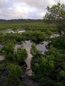
Summary.mw-parser-output table.commons-file-information-table,.mw-parser-output.fileinfotpl-type-information{border:1px solid #a2a9b1;background-color:#f8f9fa;padding:5px;font-size:95%;border-spacing:2px;box-sizing:border-box;margin:0;width:100%}.mw-parser-output table.commons-file-information-table>tbody>tr,.mw-parser-output.fileinfotpl-type-information>tbody>tr{vertical-align:top}.mw-parser-output table.commons-file-information-table>tbody>tr>td,.mw-parser-output table.commons-file-information-table>tbody>tr>th,.mw-parser-output.fileinfotpl-type-information>tbody>tr>td,.mw-parser-output.fileinfotpl-type-information>tbody>tr>th{padding:4px}.mw-parser-output.fileinfo-paramfield{background:#ccf;text-align:right;padding-right:0.4em;width:15%;font-weight:bold}.mw-parser-output.commons-file-information-table+table.commons-file-information-table,.mw-parser-output.commons-file-information-table+div.commons-file-information-table>table{border-top:0;padding-top:0;margin-top:-8px}@media only screen and (max-width:719px){.mw-parser-output table.commons-file-information-table,.mw-parser-output.commons-file-information-table.fileinfotpl-type-information{border-spacing:0;padding:0;word-break:break-word;width:100%!important}.mw-parser-output.commons-file-information-table>tbody,.mw-parser-output.fileinfotpl-type-information>tbody{display:block}.mw-parser-output.commons-file-information-table>tbody>tr>td,.mw-parser-output.commons-file-information-table>tbody>tr>th,.mw-parser-output.fileinfotpl-type-information>tbody>tr>td,.mw-parser-output.fileinfotpl-type-information>tbody>tr>th{padding:0.2em 0.4em;text-align:left;text-align:start}.mw-parser-output.commons-file-information-table>tbody>tr,.mw-parser-output.fileinfotpl-type-information>tbody>tr{display:flex;flex-direction:column}.mw-parser-output.commons-file-information-table+table.commons-file-information-table,.mw-parser-output.commons-file-information-table+div.commons-file-information-table>table{margin-top:-1px}.mw-parser-output.fileinfo-paramfield{box-sizing:border-box;flex:1 0 100%;width:100%}} Description: English: Surface water in Ferny Crofts bog, New Forest There is a broad valley to the east of Ferny Crofts, and along its axis is a mire. This point seems to be a 'ford' of sorts, where an old track (visible on aerial photographs and on the 1814 Drivers map of the New Forest) crossed the valley. The vegetation growing in the foreground is bog myrtle (Myrica gale), commonly found in the wetter parts of the New Forest heathland. Date: 16 June 2007. Source: From geograph.org.uk. Author: Jim Champion. Attribution(required by the license)InfoFieldJim Champion / Surface water in Ferny Crofts bog, New Forest / CC BY-SA 2.0. InfoFieldJim Champion / Surface water in Ferny Crofts bog, New Forest. Camera location50° 50′ 57″ N, 1° 29′ 01″ W View all coordinates using: OpenStreetMap 50.849180; -1.483700. Object location50° 50′ 57″ N, 1° 29′ 01″ W View all coordinates using: OpenStreetMap 50.849180; -1.483700.
Included On The Following Pages:
- Life (creatures)
- Cellular (cellular organisms)
- Eukaryota (eukaryotes)
- Archaeplastida (plants)
- Chloroplastida (green plants)
- Streptophyta
- Embryophytes
- Tracheophyta (ferns)
- Spermatophytes (seed plants)
- Angiosperms (Dicotyledons)
- Eudicots
- Superrosids
- Rosids
- Fagales
- Myricaceae (bayberry family)
- Myrica (sweetgale)
- Myrica gale (Bog-myrtle)
This image is not featured in any collections.
Source Information
- license
- cc-by-sa-3.0
- copyright
- Jim Champion
- creator
- Jim Champion
- source
- From geograph.org.uk
- original
- original media file
- visit source
- partner site
- Wikimedia Commons
- ID