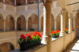
Description: English: Arcade yard of the old guildhall on the Alter Platz #1, inner city,
Klagenfurt,
Carinthia,
Austria,
EU Deutsch: Arkadenhof des Alten Rathaus am Alter Platz Nr. 1, Innere Stadt,
Klagenfurt,
Kärnten,
Österreich,
EU : This media shows the protected monument with the number
34431 in Austria. (
Commons,
de,
Wikidata) :. Date: 18 June 2009. Source: Own work. Author:
Johann Jaritz. Permission(
Reusing this file): I, the copyright holder of this work, hereby publish it under the following licenses: : Permission is granted to copy, distribute and/or modify this document under the terms of the
GNU Free Documentation License, Version 1.2 or any later version published by the
Free Software Foundation; with no Invariant Sections, no Front-Cover Texts, and no Back-Cover Texts. A copy of the license is included in the section entitled
GNU Free Documentation License.http://www.gnu.org/copyleft/fdl.htmlGFDLGNU Free Documentation Licensetruetrue. : This file is licensed under the
Creative Commons Attribution-Share Alike 3.0 Austria license. :. You are free: to share – to copy, distribute and transmit the work to remix – to adapt the work Under the following conditions: attribution – You must give appropriate credit, provide a link to the license, and indicate if changes were made. You may do so in any reasonable manner, but not in any way that suggests the licensor endorses you or your use. share alike – If you remix, transform, or build upon the material, you must distribute your contributions under the
same or compatible license as the original. https://creativecommons.org/licenses/by-sa/3.0/at/deed.en CC BY-SA 3.0 at Creative Commons Attribution-Share Alike 3.0 at truetrue. You may select the license of your choice. : The making of this work was supported by
Wikimedia Austria. For other files made with the support of Wikimedia Austria, please see the category
Supported by Wikimedia Österreich. Camera location
46° 37′ 32.18″ N, 14° 18′ 28.47″ E View all coordinates using:
OpenStreetMap 46.625606; 14.307908. Object location
46° 37′ 31.74″ N, 14° 18′ 28.37″ E View all coordinates using:
OpenStreetMap 46.625483; 14.307881. Licensing[
edit] I, the copyright holder of this work, hereby publish it under the following licenses: : Permission is granted to copy, distribute and/or modify this document under the terms of the
GNU Free Documentation License, Version 1.2 or any later version published by the
Free Software Foundation; with no Invariant Sections, no Front-Cover Texts, and no Back-Cover Texts. A copy of the license is included in the section entitled
GNU Free Documentation License.http://www.gnu.org/copyleft/fdl.htmlGFDLGNU Free Documentation Licensetruetrue. : This file is licensed under the
Creative Commons Attribution-Share Alike
3.0 Unported,
2.5 Generic,
2.0 Generic and
1.0 Generic license. :. You are free: to share – to copy, distribute and transmit the work to remix – to adapt the work Under the following conditions: attribution – You must give appropriate credit, provide a link to the license, and indicate if changes were made. You may do so in any reasonable manner, but not in any way that suggests the licensor endorses you or your use. share alike – If you remix, transform, or build upon the material, you must distribute your contributions under the
same or compatible license as the original. https://creativecommons.org/licenses/by-sa/3.0 CC BY-SA 3.0 Creative Commons Attribution-Share Alike 3.0 truetrue. You may select the license of your choice.