-
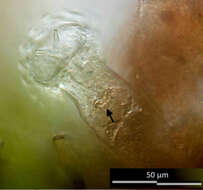
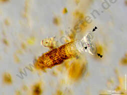
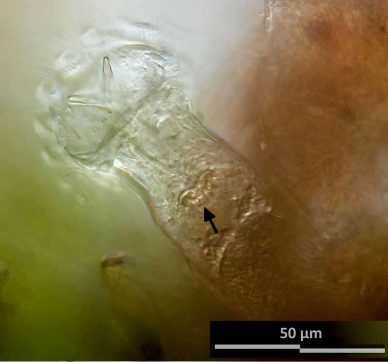
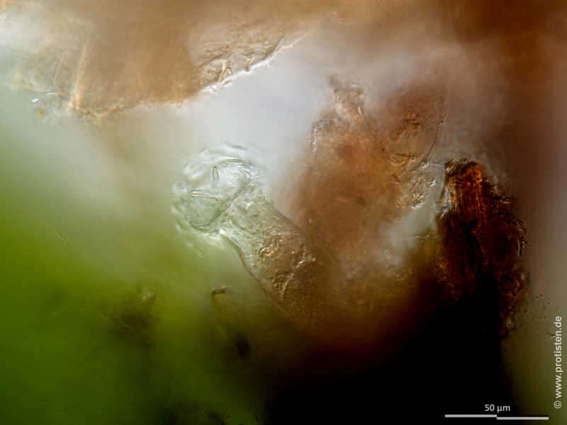
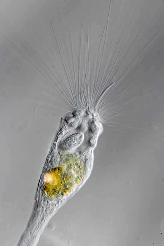
Ptygura kostei Optical section showing the trophi (arrow). Scale bar indicates 50 µm.Sample from a tropical freshwater aquarium. Sampling date 3/2023. The image was built up using several photomicrographic frames with manual stacking technique. Images were taken using Zeiss Axioplan with Olympus OM-D M5 MKII. Image under Creative Commons License V 3.0 (CC BY-NC-SA). Place name: Tropical freshwater aquarium Latitude: 54.3018013 Longitude: 10.07120132 Optischer Schnitt, der Kauer ist sichtbar (Pfeil). Multiebenen-Abbildung, manuell gestapelt. Der Messbalken markiert eine Länge von 50 µm. Probe aus einem Süßwasseraquarium. Datum der Aufsammlung: 3/2023. Mikrotechnik: Zeiss Axioplan, Kamera: Olympus OM-D M5 MKII. Creative Commons License V 3.0 (CC BY-NC-SA). For permission to use of (high-resolution) images please contact postmaster@protisten.de.
-

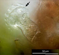
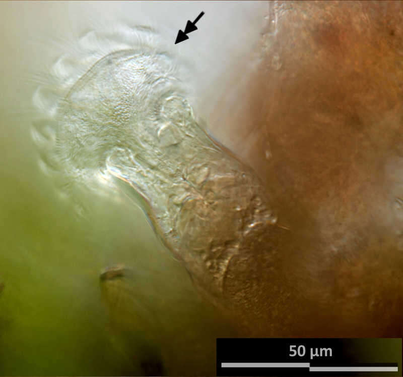
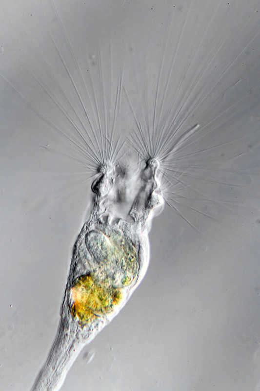
Ptygura kostei Optical section showing the nuchal fork with its base rod. Scale bar indicates 50 µm.Please press the MORE button for skipping to the annotated version.Sample from a tropical freshwater aquarium. Sampling date 3/2023. The image was built up using several photomicrographic frames with manual stacking technique. Images were taken using Zeiss Axioplan with Olympus OM-D M5 MKII. Image under Creative Commons License V 3.0 (CC BY-NC-SA). Place name: Tropical freshwater aquarium Latitude: 54.3018013 Longitude: 10.07120132 Optischer Schnitt, der die Nackengabel mit ihrem Basisstab zeigt. Multiebenen-Abbildung, manuell gestapelt. Der Messbalken markiert eine Länge von 50 µm. Bitte drücken Sie die Schaltfläche MORE, um zur kommentierten Version zu gelangen.Probe aus einem Süßwasseraquarium. Datum der Aufsammlung: 3/2023. Mikrotechnik: Zeiss Axioplan, Kamera: Olympus OM-D M5 MKII. Creative Commons License V 3.0 (CC BY-NC-SA). For permission to use of (high-resolution) images please contact postmaster@protisten.de.
-

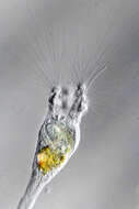
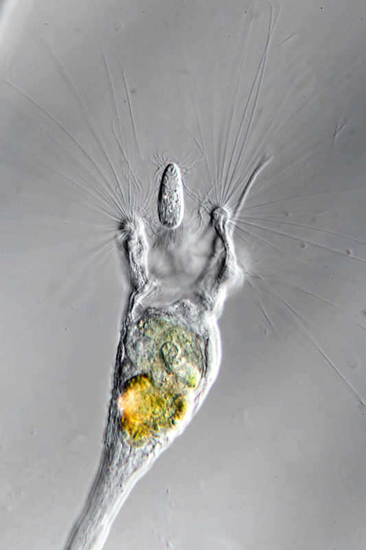
Ptygura kostei Rotifer in ventral view with fully retracted somatic body, which allows an unimpeded view of the four hooks of the nuchal fork. Scale bar indicates 50 µm.Sample from a tropical freshwater aquarium. Sampling date 3/2023. The image was built up using several photomicrographic frames with manual stacking technique. Images were taken using Zeiss Axioplan with Olympus OM-D M5 MKII. Image under Creative Commons License V 3.0 (CC BY-NC-SA). Place name: Tropical freshwater aquarium Latitude: 54.3018013 Longitude: 10.07120132 Das Rädertier hat sich nun vollkommen ausgestreckt, auch die Corona ist ganz geöffnet. Der Maßstabsbalken zeigt 100 µm an. Multiebenen-Abbildung, manuell gestapelt. Der Messbalken markiert eine Länge von 100 µm. Probe aus einem Süßwasseraquarium. Datum der Aufsammlung: 3/2023. Mikrotechnik: Zeiss Axioplan, Kamera: Olympus OM-D M5 MKII. Creative Commons License V 3.0 (CC BY-NC-SA). For permission to use of (high-resolution) images please contact postmaster@protisten.de.
-
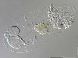
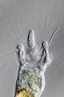
Ptygura kostei Optical section showing the fully opened corona.Scale bar indicates 50 µm.Please press the MORE button for skipping to the annotated version.Sample from a tropical freshwater aquarium. Sampling date 3/2023. The image was built up using several photomicrographic frames with manual stacking technique. Images were taken using Zeiss Axioplan with Olympus OM-D M5 MKII. Image under Creative Commons License V 3.0 (CC BY-NC-SA). Place name: Tropical freshwater aquarium Latitude: 54.3018013 Longitude: 10.07120132 Optischer Schnitt, die voll geöffnete Corona ist sichtbar. Multiebenen-Abbildung, manuell gestapelt. Der Messbalken markiert eine Länge von 50 µm. Bitte drücken Sie die Schaltfläche MORE, um zur kommentierten Version zu gelangen.Probe aus einem Süßwasseraquarium. Datum der Aufsammlung: 3/2023. Mikrotechnik: Zeiss Axioplan, Kamera: Olympus OM-D M5 MKII. Creative Commons License V 3.0 (CC BY-NC-SA). For permission to use of (high-resolution) images please contact postmaster@protisten.de.
-
Ptygura kostei The rotifer has now stretched out completely, and the corona is also fully opened. Scale bar indicates 100 µm. Sample from a tropical freshwater aquarium. Sampling date 3/2023. The image was built up using several photomicrographic frames with manual stacking technique. Images were taken using Zeiss Axioplan with Olympus OM-D M5 MKII. Image under Creative Commons License V 3.0 (CC BY-NC-SA). Place name: Tropical freshwater aquarium Latitude: 54.3018013 Longitude: 10.07120132 Das Rädertier hat sich nun vollkommen ausgestreckt, auch die Corona ist voll geöffnet. Der Maßstabsbalken zeigt 100 µm an. Multiebenen-Abbildung, manuell gestapelt. Der Messbalken markiert eine Länge von 100 µm. Probe aus einem Süßwasseraquarium. Datum der Aufsammlung: 3/2023. Mikrotechnik: Zeiss Axioplan, Kamera: Olympus OM-D M5 MKII. Creative Commons License V 3.0 (CC BY-NC-SA). For permission to use of (high-resolution) images please contact postmaster@protisten.de.
-
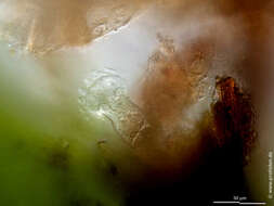
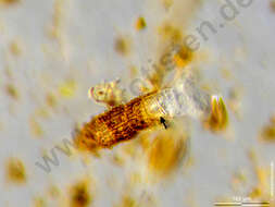
Ptygura kostei Optical section showing the trophi. Scale bar indicates 50 µm.Please press the MORE button for skipping to the annotated version.Sample from a tropical freshwater aquarium. Sampling date 3/2023. The image was built up using several photomicrographic frames with manual stacking technique. Images were taken using Zeiss Axioplan with Olympus OM-D M5 MKII. Image under Creative Commons License V 3.0 (CC BY-NC-SA). Place name: Tropical freshwater aquarium Latitude: 54.3018013 Longitude: 10.07120132 Optischer Schnitt, der Kauer ist sichtbar. Multiebenen-Abbildung, manuell gestapelt. Der Messbalken markiert eine Länge von 50 µm. Bitte drücken Sie die Schaltfläche MORE, um zur kommentierten Version zu gelangen.Probe aus einem Süßwasseraquarium. Datum der Aufsammlung: 3/2023. Mikrotechnik: Zeiss Axioplan, Kamera: Olympus OM-D M5 MKII. Creative Commons License V 3.0 (CC BY-NC-SA). For permission to use of (high-resolution) images please contact postmaster@protisten.de.
-
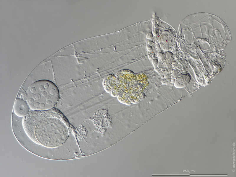
Asplanchna priodonta Scale bar indicates 250 µm. The specimen was gathered in a Pond in the forest of Altenholz-Stift near Kiel (Schleswig-Holstein, Germany). Images were taken using Zeiss Axioskop with Olympus OM-D M5 MKII. Image under Creative Commons License V 3.0 (CC BY-NC-SA). Place name: Pond in the forest of Altenholz-Stift (Schleswig-Holstein, Germany) Latitude: 54.384913 Longitude: 10.125691 Der Messbalken markiert eine Länge von 250 µm. Die Probe wurde in einem Waldteich bei Altenholz-Stift (nahe Kiel) gesammelt. Mikrotechnik: Zeiss Axioplan, Kamera: Olympus OM-D M5 MKII. Creative Commons License V 3.0 (CC BY-NC-SA). For permission to use of (high-resolution) images please contact postmaster@protisten.de.
-

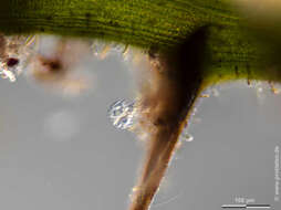
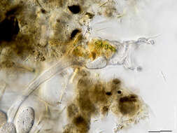
Philodina megalotrocha We see the foot-tail with the two spurs. The foot is partially retracted, which becomes visible through the annulated integument. Eyespots and trophi are also visible. Scale bar indicates 50 µm. Please press the MORE button for skipping to the annotated version.Sample from a tropical freshwater aquarium. Sampling date 3/2023. The image was built up using several photomicrographic frames with manual stacking technique. Images were taken using Zeiss Axioplan with Olympus OM-D M5 MKII. Image under Creative Commons License V 3.0 (CC BY-NC-SA). Place name: Tropical freshwater aquarium Latitude: 54.3018013 Longitude: 10.07120132 Das Bild zeigt den Fuß mit den Sporen. Der Fuß ist teilweise eingezogen, was das geringelte Integument anzeigt. Augenflecken und Kauer sind ebenfalls sichtbar. Der Messbalken markiert eine Länge von 50 µm. Bitte drücken Sie die Schaltfläche MORE, um zur kommentierten Version zu gelangen.Probe aus einem Süßwasseraquarium. Datum der Aufsammlung: 3/2023. Mikrotechnik: Zeiss Axioplan, Kamera: Olympus OM-D M5 MKII. Creative Commons License V 3.0 (CC BY-NC-SA). For permission to use of (high-resolution) images please contact postmaster@protisten.de.
-
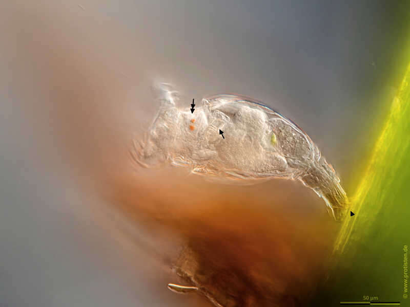
Philodina megalotrocha We see the foot-tail with the two spurs (arrowhead). The foot is partially retracted, which becomes visible through the annulated integument. Eyespots (double headed arrow), trophi (arrow). Scale bar indicates 50 µm.Sample from a tropical freshwater aquarium. Sampling date 3/2023. The image was built up using several photomicrographic frames with manual stacking technique. Images were taken using Zeiss Axioplan with Olympus OM-D M5 MKII. Image under Creative Commons License V 3.0 (CC BY-NC-SA). Place name: Tropical freshwater aquarium Latitude: 54.3018013 Longitude: 10.07120132 Das Bild zeigt den Fuß mit den Sporen (Pfeilspitze). Der Fuß ist teilweise eingezogen, was das geringelte Integument anzeigt. Augenflecken (Doppelkopfpfeil), Kauer (Pfeil). Der Messbalken markiert eine Länge von 50 µm. Probe aus einem Süßwasseraquarium. Datum der Aufsammlung: 3/2023. Mikrotechnik: Zeiss Axioplan, Kamera: Olympus OM-D M5 MKII. Creative Commons License V 3.0 (CC BY-NC-SA). For permission to use of (high-resolution) images please contact postmaster@protisten.de.
-
Philodina megalotrocha The focal plane is on the antenna. Scale bar indicates 50 µm.Sample from a tropical freshwater aquarium. Sampling date 3/2023. The image was built up using several photomicrographic frames with manual stacking technique. Images were taken using Zeiss Axioplan with Olympus OM-D M5 MKII. Image under Creative Commons License V 3.0 (CC BY-NC-SA). Place name: Tropical freshwater aquarium Latitude: 54.3018013 Longitude: 10.07120132 Die Schärfenebene der Aufnahme liegt auf dem Taster. Der Messbalken markiert eine Länge von 50 µm. Probe aus einem Süßwasseraquarium. Datum der Aufsammlung: 3/2023. Mikrotechnik: Zeiss Axioplan, Kamera: Olympus OM-D M5 MKII. Creative Commons License V 3.0 (CC BY-NC-SA). For permission to use of (high-resolution) images please contact postmaster@protisten.de.
-
Philodina megalotrocha The focal plane is on the eyespots. Scale bar indicates 50 µm.Sample from a tropical freshwater aquarium. Sampling date 3/2023. The image was built up using several photomicrographic frames with manual stacking technique. Images were taken using Zeiss Axioplan with Olympus OM-D M5 MKII. Image under Creative Commons License V 3.0 (CC BY-NC-SA). Place name: Tropical freshwater aquarium Latitude: 54.3018013 Longitude: 10.07120132 Die Schärfenebene der Aufnahme liegt auf den Augenflecken. Der Messbalken markiert eine Länge von 50 µm. Probe aus einem Süßwasseraquarium. Datum der Aufsammlung: 3/2023. Mikrotechnik: Zeiss Axioplan, Kamera: Olympus OM-D M5 MKII. Creative Commons License V 3.0 (CC BY-NC-SA). For permission to use of (high-resolution) images please contact postmaster@protisten.de.
-
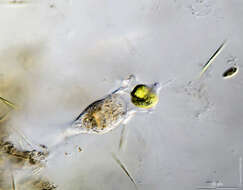
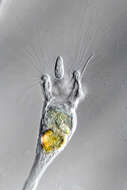
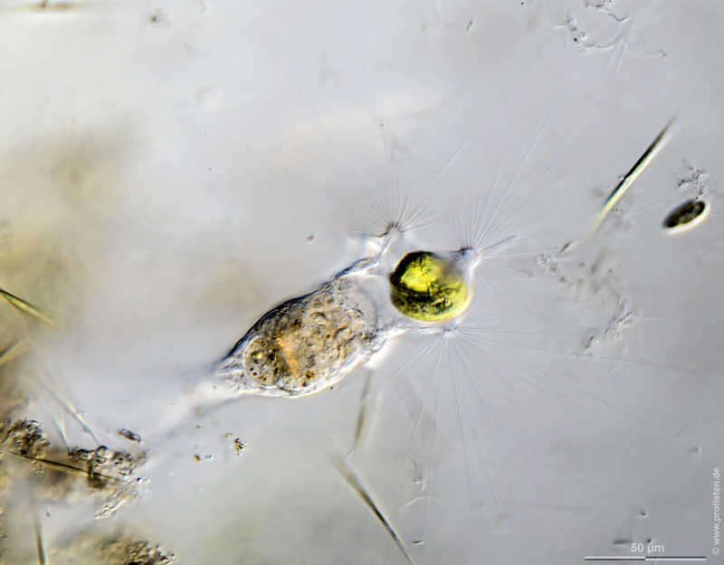
Collotheca ornata Scale bar indicates 25 µm. The specimen was gathered in a tiny freshwater pond called Suploch on the island of Hiddensee (Baltic Sea, Germany). Sampling date 10/2018. The image was built up using several photomicrographic frames with manual stacking technique. Images were taken using Zeiss Standard with Olympus OM-D M5 MKII. Image under Creative Commons License V 3.0 (CC BY-NC-SA). Place name: Pond Suploch, Hiddensee (Germany) Latitude: 54.538638 Longitude: 13.097802 Multiebenen-Abbildung, manuell gestapelt. Der Messbalken markiert eine Länge von 25 µm. Probe aus dem Suploch, einem kleinen Süßwasserteich auf der Insel Hiddensee. Datum der Aufsammlung: 10/2018. Mikrotechnik: Zeiss Standard, Kamera: Olympus OM-D M5 MKII. Creative Commons License V 3.0 (CC BY-NC-SA). For permission to use of (high-resolution) images please contact postmaster@protisten.de.
-
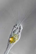
Collotheca ornata Scale bar indicates 50 µm. The specimen was gathered in a tiny freshwater pond called Suploch on the island of Hiddensee (Baltic Sea, Germany). Sampling date 10/2018. The image was built up using several photomicrographic frames with manual stacking technique. Images were taken using Zeiss Standard with Olympus OM-D M5 MKII. Image under Creative Commons License V 3.0 (CC BY-NC-SA). Place name: Pond Suploch, Hiddensee (Germany) Latitude: 54.538638 Longitude: 13.097802 Multiebenen-Abbildung, manuell gestapelt. Der Messbalken markiert eine Länge von 50 µm. Probe aus dem Suploch, einem kleinen Süßwasserteich auf der Insel Hiddensee. Datum der Aufsammlung: 10/2018. Mikrotechnik: Zeiss Standard, Kamera: Olympus OM-D M5 MKII. Creative Commons License V 3.0 (CC BY-NC-SA). For permission to use of (high-resolution) images please contact postmaster@protisten.de.
-
Collotheca ornata The specimen was gathered in the pond Birkensee near Rödelsee (Lower Franconia, Germany). Copyright Dr. Rainer Meisch, Würzburg, Germany.Images were taken using Zeiss Axioplan with Canon DSLR Image under Creative Commons License V 3.0 (CC BY-NC-SA). Place name: Pond Birkensee near Rödelsee (Lower Franconia, Germany) Latitude: 49.71819841 Longitude: 10.27807474 Probe aus dem Birkensee bei Rödelsee (Unterfranken). Datum der Aufsammlung: 7/2018. Copyright Dr. Rainer Meisch, Würzburg. Mikrotechnik: Zeiss Axioplan, Kamera: Canon DSLR. Creative Commons License V 3.0 (CC BY-NC-SA). For permission to use of (high-resolution) images please contact postmaster@protisten.de.
-
Collotheca ornata Scale bar indicates 25 µm. The specimen was gathered in a tiny freshwater pond called Suploch on the island of Hiddensee (Baltic Sea, Germany). Sampling date 10/2018. The image was built up using several photomicrographic frames with manual stacking technique. Images were taken using Zeiss Standard with Olympus OM-D M5 MKII. Image under Creative Commons License V 3.0 (CC BY-NC-SA). Place name: Pond Suploch, Hiddensee (Germany) Latitude: 54.538638 Longitude: 13.097802 Multiebenen-Abbildung, manuell gestapelt. Der Messbalken markiert eine Länge von 25 µm. Probe aus dem Suploch, einem kleinen Süßwasserteich auf der Insel Hiddensee. Datum der Aufsammlung: 10/2018. Mikrotechnik: Zeiss Standard, Kamera: Olympus OM-D M5 MKII. Creative Commons License V 3.0 (CC BY-NC-SA). For permission to use of (high-resolution) images please contact postmaster@protisten.de.
-
Collotheca ornata The specimen was gathered in the pond Birkensee near Rödelsee (Lower Franconia, Germany). Copyright Dr. Rainer Meisch, Würzburg, Germany.Images were taken using Zeiss Axioplan with Canon DSLR Image under Creative Commons License V 3.0 (CC BY-NC-SA). Place name: Pond Birkensee near Rödelsee (Lower Franconia, Germany) Latitude: 49.71819841 Longitude: 10.27807474 Probe aus dem Birkensee bei Rödelsee (Unterfranken). Datum der Aufsammlung: 7/2018. Copyright Dr. Rainer Meisch, Würzburg. Mikrotechnik: Zeiss Axioplan, Kamera: Canon DSLR. Creative Commons License V 3.0 (CC BY-NC-SA). For permission to use of (high-resolution) images please contact postmaster@protisten.de.
-

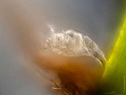
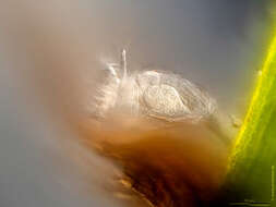
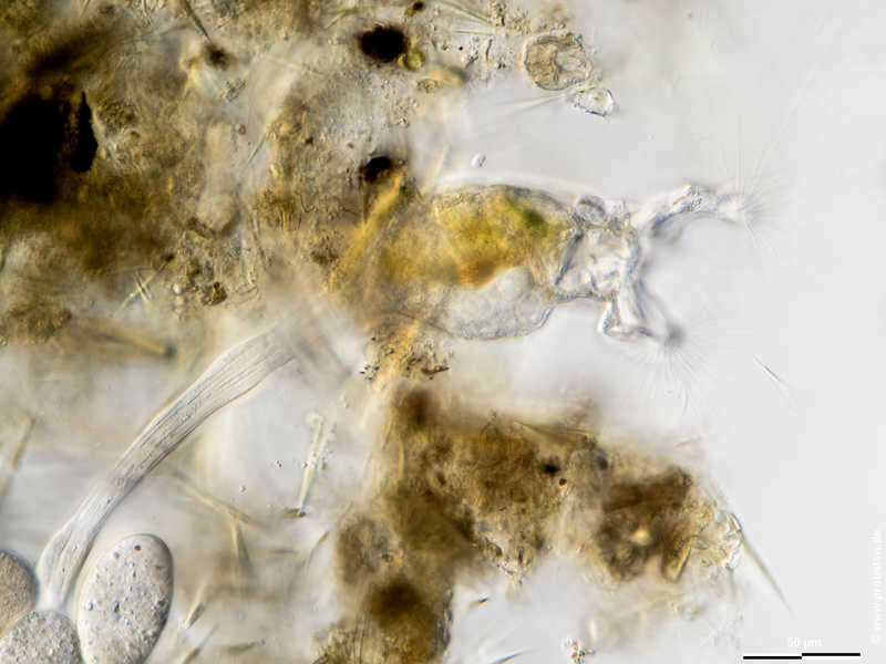
Rotaria tardigrada Eye spots, corona. Please press the MORE button for skipping to the annotated version.Scale bar indicates 100 µm. The specimen was gathered in the wetlands of Nationalpark Unteres Odertal (100 km north east of Berlin). Sampling date 5/2022. Images were taken using Olympus stereo microscope SZX16/Planapo 2.0x with Olympus OM-D M5 MKII. Image under Creative Commons License V 3.0 (CC BY-NC-SA). Place name: Creek in Oder valley 100 km north east of Berlin (Germany) Latitude: 53.135032 Longitude: 14.348738 Augenflecken, Räderorgan. Bitte drücken Sie die Schaltfläche MORE, um zur kommentierten Version zu gelangen.Der Messbalken markiert eine Länge von 100 µm. Probe aus einem Feuchtbiotop im Nationalpark Unteres Odertal auf halber Strecke zwischen Schwedt und Gartz. Datum der Aufsammlung: 5/2022. Mikrotechnik: Olympus stereo microscope SZX16/Planapo 2.0x, Kamera: Olympus OM-D M5 MKII. Creative Commons License V 3.0 (CC BY-NC-SA). For permission to use of (high-resolution) images please contact postmaster@protisten.de.
-

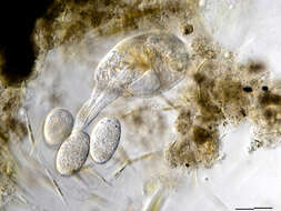
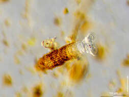
Rotaria tardigrada Integument covered by brown detritus, ramate trophy. Please press the MORE button for skipping to the annotated version.Scale bar indicates 100 µm. The specimen was gathered in the wetlands of Nationalpark Unteres Odertal (100 km north east of Berlin). Sampling date 5/2022. Images were taken using Olympus stereo microscope SZX16/Planapo 2.0x with Olympus OM-D M5 MKII. Image under Creative Commons License V 3.0 (CC BY-NC-SA). Place name: Creek in Oder valley 100 km north east of Berlin (Germany) Latitude: 53.135032 Longitude: 14.348738 Das Integument ist mit braunem Detritus bedeckt, der ramate (reibende) Kauer ist sichtbar. Bitte drücken Sie die Schaltfläche MORE, um zur kommentierten Version zu gelangen. Der Messbalken markiert eine Länge von 100 µm. Probe aus einem Feuchtbiotop im Nationalpark Unteres Odertal auf halber Strecke zwischen Schwedt und Gartz. Datum der Aufsammlung: 5/2022. Mikrotechnik: Olympus stereo microscope SZX16/Planapo 2.0x, Kamera: Olympus OM-D M5 MKII. Creative Commons License V 3.0 (CC BY-NC-SA). For permission to use of (high-resolution) images please contact postmaster@protisten.de.
-
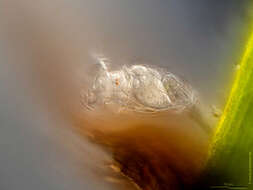
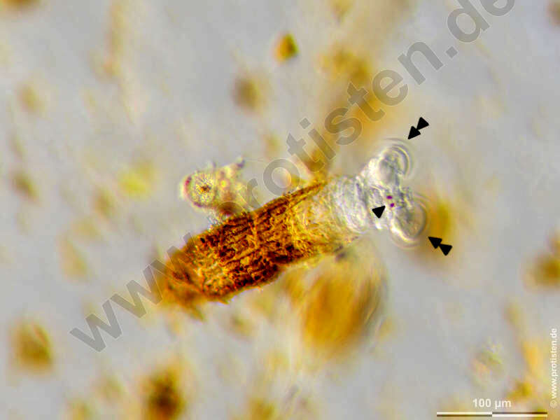
Rotaria tardigrada Eye spots (arrowhead), corona (double arrowhead). Scale bar indicates 100 µm. The specimen was gathered in the wetlands of Nationalpark Unteres Odertal (100 km north east of Berlin). Sampling date 5/2022. Images were taken using Olympus stereo microscope SZX16/Planapo 2.0x with Olympus OM-D M5 MKII. Image under Creative Commons License V 3.0 (CC BY-NC-SA). Place name: Creek in Oder valley 100 km north east of Berlin (Germany) Latitude: 53.135032 Longitude: 14.348738 Augenflecken (Pfeilspitze), Räderorgan (Doppelpfeilspitze). Der Messbalken markiert eine Länge von 100 µm. Probe aus einem Feuchtbiotop im Nationalpark Unteres Odertal auf halber Strecke zwischen Schwedt und Gartz. Datum der Aufsammlung: 5/2022. Mikrotechnik: Olympus stereo microscope SZX16/Planapo 2.0x, Kamera: Olympus OM-D M5 MKII. Creative Commons License V 3.0 (CC BY-NC-SA). For permission to use of (high-resolution) images please contact postmaster@protisten.de.
-

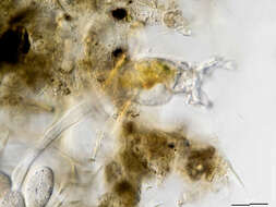
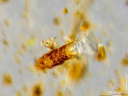
Rotaria tardigrada Integument covered by brown detritus, ramate trophy (arrow). Scale bar indicates 100 µm. The specimen was gathered in the wetlands of Nationalpark Unteres Odertal (100 km north east of Berlin). Sampling date 5/2022. Images were taken using Olympus stereo microscope SZX16/Planapo 2.0x with Olympus OM-D M5 MKII. Image under Creative Commons License V 3.0 (CC BY-NC-SA). Place name: Creek in Oder valley 100 km north east of Berlin (Germany) Latitude: 53.135032 Longitude: 14.348738 Das Integument ist mit braunem Detritus bedeckt, der ramate (reibende) Kauer (Pfeil) ist sichtbar. Der Messbalken markiert eine Länge von 100 µm. Probe aus einem Feuchtbiotop im Nationalpark Unteres Odertal auf halber Strecke zwischen Schwedt und Gartz. Datum der Aufsammlung: 5/2022. Mikrotechnik: Olympus stereo microscope SZX16/Planapo 2.0x, Kamera: Olympus OM-D M5 MKII. Creative Commons License V 3.0 (CC BY-NC-SA). For permission to use of (high-resolution) images please contact postmaster@protisten.de.