Stewartia malacodendron range map
Description:
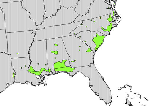
Description: English: Range map of Stewartia malacodendron. Date: 1999. Source: http://en.wikipedia.org/wiki/File:Stewartia_malacodendron_range_map.jpg Digital representation of "Atlas of United States Trees" by Elbert L. Little, Jr. [1]. Author: U.S. Geological Survey. Permission(Reusing this file): Public domainPublic domainfalsefalse. : This image is in the public domain in the United States because it only contains materials that originally came from the United States Geological Survey, an agency of the United States Department of the Interior. For more information, see the official USGS copyright policy. Bahasa Indonesia ∙ català ∙ čeština ∙ Deutsch ∙ eesti ∙ English ∙ español ∙ français ∙ galego ∙ italiano ∙ Nederlands ∙ português ∙ polski ∙ sicilianu ∙ suomi ∙ Tiếng Việt ∙ Türkçe ∙ български ∙ македонски ∙ русский ∙ മലയാളം ∙ 한국어 ∙ 日本語 ∙ 中文 ∙ 中文(简体) ∙ 中文(繁體) ∙ العربية ∙ فارسی ∙ +/− :.
Included On The Following Pages:
- Life (creatures)
- Cellular (cellular organisms)
- Eukaryota (eukaryotes)
- Archaeplastida (plants)
- Chloroplastida (green plants)
- Streptophyta
- Embryophytes
- Tracheophyta (ferns)
- Spermatophytes (seed plants)
- Angiosperms (Dicotyledons)
- Eudicots
- Superasterids
- Asterids
- Ericales
- Theaceae (tea family)
- Stewartia (stewartia)
- Stewartia malacodendron (Silky Camellia)
This image is not featured in any collections.
![http://en.wikipedia.org/wiki/File:Stewartia_malacodendron_range_map.jpg Digital representation of "Atlas of United States Trees" by Elbert L. Little, Jr. [1]](http://en.wikipedia.org/wiki/File:Stewartia_malacodendron_range_map.jpg)