Expedition 10
Description:
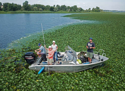
Summary.mw-parser-output table.commons-file-information-table,.mw-parser-output.fileinfotpl-type-information{border:1px solid #a2a9b1;background-color:#f8f9fa;padding:5px;font-size:95%;border-spacing:2px;box-sizing:border-box;margin:0;width:100%}.mw-parser-output table.commons-file-information-table>tbody>tr,.mw-parser-output.fileinfotpl-type-information>tbody>tr{vertical-align:top}.mw-parser-output table.commons-file-information-table>tbody>tr>td,.mw-parser-output table.commons-file-information-table>tbody>tr>th,.mw-parser-output.fileinfotpl-type-information>tbody>tr>td,.mw-parser-output.fileinfotpl-type-information>tbody>tr>th{padding:4px}.mw-parser-output.fileinfo-paramfield{background:#ccf;text-align:right;padding-right:0.4em;width:15%;font-weight:bold}.mw-parser-output.commons-file-information-table+table.commons-file-information-table,.mw-parser-output.commons-file-information-table+div.commons-file-information-table>table{border-top:0;padding-top:0;margin-top:-8px}@media only screen and (max-width:719px){.mw-parser-output table.commons-file-information-table,.mw-parser-output.commons-file-information-table.fileinfotpl-type-information{border-spacing:0;padding:0;word-break:break-word;width:100%!important}.mw-parser-output.commons-file-information-table>tbody,.mw-parser-output.fileinfotpl-type-information>tbody{display:block}.mw-parser-output.commons-file-information-table>tbody>tr>td,.mw-parser-output.commons-file-information-table>tbody>tr>th,.mw-parser-output.fileinfotpl-type-information>tbody>tr>td,.mw-parser-output.fileinfotpl-type-information>tbody>tr>th{padding:0.2em 0.4em;text-align:left;text-align:start}.mw-parser-output.commons-file-information-table>tbody>tr,.mw-parser-output.fileinfotpl-type-information>tbody>tr{display:flex;flex-direction:column}.mw-parser-output.commons-file-information-table+table.commons-file-information-table,.mw-parser-output.commons-file-information-table+div.commons-file-information-table>table{margin-top:-1px}.mw-parser-output.fileinfo-paramfield{box-sizing:border-box;flex:1 0 100%;width:100%}} Description: Українська: Комплексне дослідження акваторії Канівського водосховища в зоні розповсюдження водяного горіху (Trapa natans L.) в серпні 2021 р. у рамках наукового проекту «Вплив заростання водосховищ вищими водними рослинами на процеси цвітіння та рибопродуктивність». Вчені Інституту Гідробіології НАНУ проводять батиметричні та фізикохімічні вимірювання, зокрема виміри швидкості течії з використанням приладу OTT MF pro Water Flow Meter, відбирають іхтіологічні зразки та проби води. Експерт з дистанційного зондування виконує картування території з БПЛА для валідації супутникових даних. Фото отримане за допомогою дрону Dji mavic pro (на висоті більше 30 м).English: Comprehensive study of the water area of the Kaniv Reservoir in the area of distribution of of the water nut (Trapa natans L.) in August 2021 in the research project " Influence of overgrowing reservoirs with higher aquatic plants on flowering processes and fish productivity". Scientists of the Institute of Hydrobiology of the National Academy of Sciences of Ukraine perform bathymetric and physicochemical measurements, in particular measurements of flow velocity using the OTT MF pro Water Flow Meter, take ichthyological samples and water samples. A remote sensing expert maps the area with a UAV to validate satellite data. The photo obtained with the drone Dji mavic pro drone (at a height of more than 30 m). Date: 2 August 2021, 11:41:02. Source: Own work. Author: Bilous Olena. Camera location50° 09′ 56.94″ N, 30° 46′ 44.77″ E View all coordinates using: OpenStreetMap 50.165816; 30.779104.
Included On The Following Pages:
- Life (creatures)
- Cellular (cellular organisms)
- Eukaryota (eukaryotes)
- Archaeplastida (plants)
- Chloroplastida (green plants)
- Streptophyta
- Embryophytes
- Tracheophyta (ferns)
- Spermatophytes (seed plants)
- Angiosperms (Dicotyledons)
- Eudicots
- Superrosids
- Rosids
- Myrtales (Myrtle Order)
- Lythraceae (loosestrife family)
- Trapa (water chestnut)
- Trapa natans (Jesuit's nut)
This image is not featured in any collections.
Source Information
- license
- cc-by-3.0
- copyright
- Bilous Olena
- creator
- Bilous Olena
- original
- original media file
- visit source
- partner site
- Wikimedia Commons
- ID