Rubha an Iasgaich - geograph.org.uk - 1465805
Description:
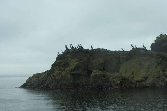
Summary.mw-parser-output table.commons-file-information-table,.mw-parser-output.fileinfotpl-type-information{border:1px solid #a2a9b1;background-color:#f8f9fa;padding:5px;font-size:95%;border-spacing:2px;box-sizing:border-box;margin:0;width:100%}.mw-parser-output table.commons-file-information-table>tbody>tr,.mw-parser-output.fileinfotpl-type-information>tbody>tr{vertical-align:top}.mw-parser-output table.commons-file-information-table>tbody>tr>td,.mw-parser-output table.commons-file-information-table>tbody>tr>th,.mw-parser-output.fileinfotpl-type-information>tbody>tr>td,.mw-parser-output.fileinfotpl-type-information>tbody>tr>th{padding:4px}.mw-parser-output.fileinfo-paramfield{background:#ccf;text-align:right;padding-right:0.4em;width:15%;font-weight:bold}.mw-parser-output.commons-file-information-table+table.commons-file-information-table,.mw-parser-output.commons-file-information-table+div.commons-file-information-table>table{border-top:0;padding-top:0;margin-top:-8px}@media only screen and (max-width:719px){.mw-parser-output table.commons-file-information-table,.mw-parser-output.commons-file-information-table.fileinfotpl-type-information{border-spacing:0;padding:0;word-break:break-word;width:100%!important}.mw-parser-output.commons-file-information-table>tbody,.mw-parser-output.fileinfotpl-type-information>tbody{display:block}.mw-parser-output.commons-file-information-table>tbody>tr>td,.mw-parser-output.commons-file-information-table>tbody>tr>th,.mw-parser-output.fileinfotpl-type-information>tbody>tr>td,.mw-parser-output.fileinfotpl-type-information>tbody>tr>th{padding:0.2em 0.4em;text-align:left;text-align:start}.mw-parser-output.commons-file-information-table>tbody>tr,.mw-parser-output.fileinfotpl-type-information>tbody>tr{display:flex;flex-direction:column}.mw-parser-output.commons-file-information-table+table.commons-file-information-table,.mw-parser-output.commons-file-information-table+div.commons-file-information-table>table{margin-top:-1px}.mw-parser-output.fileinfo-paramfield{box-sizing:border-box;flex:1 0 100%;width:100%}} Description: English: Rubha an Iasgaich This small headland is usually populated with many shags. The island of Eilean Chathastail, of which this headland is its most Easterly point, is formed from basalt. Date: 20 August 2008. Source: From geograph.org.uk. Author: George Brown. Attribution(required by the license)InfoFieldGeorge Brown / Rubha an Iasgaich / CC BY-SA 2.0. InfoFieldGeorge Brown / Rubha an Iasgaich. Camera location56° 52′ 23.8″ N, 6° 07′ 13.8″ W View all coordinates using: OpenStreetMap 56.873278; -6.120510. Object location56° 52′ 16.23″ N, 6° 07′ 13.7″ W View all coordinates using: OpenStreetMap 56.871175; -6.120470.
Included On The Following Pages:
- Life (creatures)
- Cellular (cellular organisms)
- Eukaryota (eukaryotes)
- Opisthokonta (opisthokonts)
- Metazoa (Animal)
- Bilateria
- Deuterostomia (deuterostomes)
- Chordata (Chordates)
- Vertebrata (vertebrates)
- Gnathostomata (jawed fish)
- Osteichthyes
- Sarcopterygii (Lobe-finned fishes)
- Tetrapoda (terrestrial vertebrates)
- Amniota (amniotes)
- Reptilia (Reptiles)
- Diapsida (diapsid)
- Archosauromorpha (archosauromorph)
- Archosauria (Archosaurs)
- Dinosauria (dinosaurs and birds)
- Saurischia
- Theropoda (theropods)
- Tetanurae (tetanuran theropod)
- Coelurosauria (coelurosaur)
- Maniraptoriformes
- Maniraptora (maniraptoran)
- Aves (birds)
- Ornithurae
- Neornithes
- Neognathae (Neognaths)
- Neoaves
- waterbirds
- Suliformes
- Phalacrocoracidae (cormorants)
- Phalacrocorax
- Phalacrocorax aristotelis (European Shag)
This image is not featured in any collections.
Source Information
- license
- cc-by-sa-3.0
- copyright
- George Brown
- creator
- George Brown
- source
- From geograph.org.uk
- original
- original media file
- visit source
- partner site
- Wikimedia Commons
- ID