Tangle near Lang Craig - geograph.org.uk - 1460902
Description:
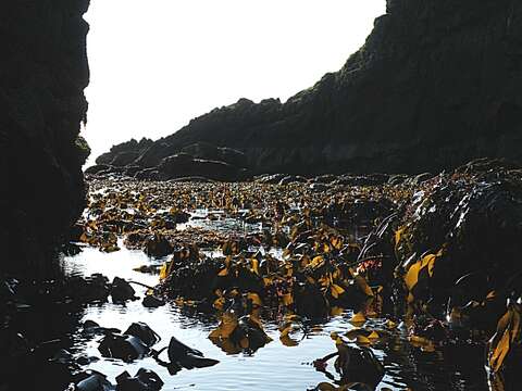
Summary.mw-parser-output table.commons-file-information-table,.mw-parser-output.fileinfotpl-type-information{border:1px solid #a2a9b1;background-color:#f8f9fa;padding:5px;font-size:95%;border-spacing:2px;box-sizing:border-box;margin:0;width:100%}.mw-parser-output table.commons-file-information-table>tbody>tr,.mw-parser-output.fileinfotpl-type-information>tbody>tr{vertical-align:top}.mw-parser-output table.commons-file-information-table>tbody>tr>td,.mw-parser-output table.commons-file-information-table>tbody>tr>th,.mw-parser-output.fileinfotpl-type-information>tbody>tr>td,.mw-parser-output.fileinfotpl-type-information>tbody>tr>th{padding:4px}.mw-parser-output.fileinfo-paramfield{background:#ccf;text-align:right;padding-right:0.4em;width:15%;font-weight:bold}.mw-parser-output.commons-file-information-table+table.commons-file-information-table,.mw-parser-output.commons-file-information-table+div.commons-file-information-table>table{border-top:0;padding-top:0;margin-top:-8px}@media only screen and (max-width:719px){.mw-parser-output table.commons-file-information-table,.mw-parser-output.commons-file-information-table.fileinfotpl-type-information{border-spacing:0;padding:0;word-break:break-word;width:100%!important}.mw-parser-output.commons-file-information-table>tbody,.mw-parser-output.fileinfotpl-type-information>tbody{display:block}.mw-parser-output.commons-file-information-table>tbody>tr>td,.mw-parser-output.commons-file-information-table>tbody>tr>th,.mw-parser-output.fileinfotpl-type-information>tbody>tr>td,.mw-parser-output.fileinfotpl-type-information>tbody>tr>th{padding:0.2em 0.4em;text-align:left;text-align:start}.mw-parser-output.commons-file-information-table>tbody>tr,.mw-parser-output.fileinfotpl-type-information>tbody>tr{display:flex;flex-direction:column}.mw-parser-output.commons-file-information-table+table.commons-file-information-table,.mw-parser-output.commons-file-information-table+div.commons-file-information-table>table{margin-top:-1px}.mw-parser-output.fileinfo-paramfield{box-sizing:border-box;flex:1 0 100%;width:100%}} Description: English: Tangle near Lang Craig. This looks as if it had been taken from a cave, but in fact it wasn't. The rock wall on the left is a sea stack, and if I'd floated a couple of feet further to the right Lang Craig would have been visible. However I'd have been looking straight into the sun and I wouldn't have been able to take this photograph. The tangle (Oarweed, Laminaria digitata) is sticking far enough up from the water surface to warn me that it's probably too shallow to pass through, even for my kayak. The rock at the right is the end of the cliff which contains 1460889. Date: 22 August 2009. Source: From geograph.org.uk. Author: Anne Burgess. Attribution(required by the license)InfoFieldAnne Burgess / Tangle near Lang Craig / CC BY-SA 2.0. InfoFieldAnne Burgess / Tangle near Lang Craig. Camera location56° 37′ 45″ N, 2° 28′ 58″ W View all coordinates using: OpenStreetMap 56.629070; -2.482700. Object location56° 37′ 44″ N, 2° 28′ 57″ W View all coordinates using: OpenStreetMap 56.628980; -2.482400.
Included On The Following Pages:
- Life (creatures)
- Cellular (cellular organisms)
- Eukaryota (eukaryotes)
- SAR (Stramenopiles, Alveolates, Rhizaria)
- Stramenopiles (heterokont)
- Ochrophyta (Ochrophyte)
- Phaeophyceae (brown algae)
- Laminariales (kelp)
- Laminariaceae
- Laminaria (Laminaria)
- Laminaria digitata (oarweed, tangle)
This image is not featured in any collections.
Source Information
- license
- cc-by-sa-3.0
- copyright
- Anne Burgess
- creator
- Anne Burgess
- source
- From geograph.org.uk
- original
- original media file
- visit source
- partner site
- Wikimedia Commons
- ID