Image of NO NAME!
Description:
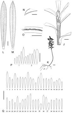
Figure 54.Distinguishing features of Kunzea robusta continued. J Vegetative bud and branchlet indumentum (no voucher, North Island, Auckland, Green Bay) K Seedling of common variant (no voucher, North Island, Albany Scenic Reserve) L Adaxial leaf surface (no voucher, North Island, Auckland Green Bay) M Abaxial leaf surface (no voucher, North Island, Auckland Green Bay) N Adaxial leaf apex (no voucher, North Island, Auckland Green Bay) O Leaf margin indumentum (no voucher, North Island, Auckland Green Bay) P Leaf variation within two individuals (P1) North Island, Auckland, Green Bay (no voucher), (P2), North Island, Hapuakohe Range, Wai Iti Road, (ex cult. AK 285561) Q Leaf variation: (Q1) North Island, Cavalli Island (AK 150268), (Q2) North Island, Whangaroa Harbour (AK 226190), (Q3) North Island, Puketi (AK 169749), (Q4) North Island, Mangatoa Stream (AK 254925), (Q5) North Island, Mokohinau Islands group (AK 226069), (Q6) North Island, Puhoi (AK 250787), (Q7) North Island, Waikawau Bay (AK 245109), (Q8) North Island, Mangatawhiri Valley (AK 208449), (Q9) North Island, Kauaeranga Valley (AK 242671), (Q10) North Island, Whangamarino (AK 242673), (Q11) North Island, Hamilton, Hammond Bush (AK 207190), (Q12) North Island, Kohioawa Beach (AK 287041), (Q13) North Island, Moutohora (Whale Island) (AK 289818), (Q14) North Island, Whakatane, Kohi Point (AK 289950), (Q15) North Island, Torere (AK 289977), (Q16) North Island, Hicks Bay (AK 285565), (Q17) North Island, Haupara Point (AK 288506), (Q18) North Island, Ruatoria (AK 286087), (Q19) North Island, Awaroa Scenic Reserve (AK 287864), (Q20) North Island, Lake Okataina (AK 288229), (Q21) North Island, Whakamaru (AK 288041), (Q22) North Island, Lake Waikaremoana (AK 287026), (Q23) North Island, Tangarakau River (AK 286129), (Q24) North Island, Kaweka Range (AK 288045), (Q25) North Island, Mahia Peninsula (AK 286160), (Q26) North Island, Frasertown (AK 287040), (Q27) North Island, Tangoio (AK 286251), (Q28) North Island, Kawhatau River (AK 288075), (Q29) North Island, Oroua (AK 288048), (Q30) North Island, Pohangina River (AK 288047), (Q31) North Island, Foxton (AK 288695), (Q32) North Island, Mangatainoka River (AK 289513), (Q33) North Island, Upper Tauweru River (AK 288023), (Q34) North Island, Putangirua Pinnacles (AK 287531), (Q35) South Island, D’Urville Island (AK 288513), (Q36) South Island Port Underwood (AK 288592), (Q37) South Island, Waima River (AK 286221), (Q38) South Island, Clarence River (AK 288569), (Q39) South Island, Happy Valley (AK 285567), (Q40) South Island, Banks Peninsula (AK 286135), (Q41) South Island, Buller River, near Westport (AK 288441), (Q42) South Island, Dunedin (AK 288441). Scale Bars: (J, L–N) 1 mm; (K, P, Q) 10 mm; (O) 0.5 mm.
Included On The Following Pages:
- NO NAME!
- Plantae (plant)
- Magnoliopsida
- Myrtales (Myrtle Order)
- Myrtaceae (myrtles)
- Kunzea (kunzea)
- Kunzea robusta
This image is not featured in any collections.
Source Information
- license
- cc-by-3.0
- copyright
- Peter J. de Lange
- bibliographic citation
- de Lange P (2014) A revision of the New Zealand Kunzea ericoides (Myrtaceae) complex PhytoKeys (40): 1–185
- original
- original media file
- visit source
- partner site
- Phytokeys
- ID