This ecoregion covers 34,900 square miles of critical/endangered deserts & xeric shrublands in Western Australia. The ecoregion's topography is chiefly low-lying, and the plantlife varies with the underlying geology, which is primarily comprised of recent alluvial, aeolian, and marine sediments over cretaceous strata. This ecoregion is extremely arid, claiming less than 250 millimetres of total precipitation per annum.
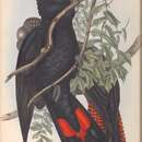
Covering the saline alluvial plains are chiefly low samphire and saltbush shrublands, withsnakewood scrublands upon the clay flats; Bowgada low woodland covers sandy ridges and plains, red sand dune fields are interspersed or overlain with tree to shrub steppe over hummock grasslands, and Acacia startii-A. bivenosa shrublands cover limestone outcrops at the north. Other tree species in the ecoregion include limestone wattle (Acacia sclerosperma) with an undergrowth of dead finish (Acacia tetragonophylla). The sheltered embayments and expansive tidal flats along the coastal zone support mangroves. Vertebrates of the ecoregion include birds such as the Thick-billed grasswren (Amytornis textilis) and the Australian endemic red-tailed black cockatoo (Calyptorhynchus banksii). This locale isthought to be the sole possible habitat for a surviving population of the lesser stick-nest rat, which is otherwise potentially extinct.